| Previous Unloads: | ||
|
1991 May: A Visit to Langkawi, the Land of Mahsuri 1991 Aug: Study tour to Medan, Indonesia 1994 May: First Asia Pacific Chitin and Chitosan Symposium (APCCS) 1995 Dec: SAS Revisited 1997 Dec: Rally Nationwide Vision 1998 Apr MOU and Launching of Chito-Chem (M) Sdn Bhd 1999 Sep: The Officiation of Smart Technology Centre, UKM 1999 Sep 23: A Week on Leave 1999 Dec: Study Tour to Taiwan 2000 Jul: A MiniReunion of Class of 66 2000 Dec: Just An Unlucky Day 2001 Jul: 29th Covocation of UKM 2001 Dec: Digging Deep Into the Root: SKBT Revisited |
2002 Sep: A Consequential Events from Feb 2002 2003 Apr: Reminiscing the Little Boy 2003 Nov: Reunion of Class of 66 2004 May: Cameron Highland Revisited 2004 Jul: In the Heart of Two Cities 2005 Jan: SAS Re-Revisited 2005 Jan: Seri Puteri Eventually Visited 2005 Apr: In the Backyard (and Frontyard) 2005 Nov: Jalan Hale Revisited 2006 May: Kenyir, Here I Come 2006 Jun: Bidong Revisited 2006 Aug: Convocation UKM #34 2006 2006 Oct: The Faces of Ramadan |
2007 Mar: Duku - The Fruit of Terengganu 2007 Nov: Ke Tepian Sang Seluang Melaut 2008 Apr: Drifted from the Past 2008 May: An Old Man and the Sea 2008 Jun: Bukit Besar - The Last Bastion 2008 Aug 08: Taken to the Memory Lane - UKM 1970 in 2008 2008 Aug 12: Kenyir Re-Visited 2008 Dec 28: The 2008 Year Event 2009 Jul 1: The Tanjong at the Muara of Terengganu River |
The Tanjong at the Muara of Terengganu River (Dated: 2009 Jul 1)
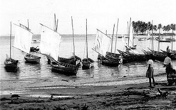 Long long time ago. In 1960's that I remembered. Kedai Tanjong and its adjacent Padang Malaya was a market place in the estuary of Terengganu river. Closest to the open South China Sea, it was the third along the southern bank of the river. Metropolitan in a sense because the town Kuala Terengganu is in it. The first was Kedai Binjai, the second was Kedai Payang which is the only survivor among the three through the developed Terengganu. Kedai Binjai was not very much a market place. It was more of the landing site for the people of Duyung, Pulau Ketam, and other peripheral islands. It was the first to go. First it became the long distance taxi stand which was a mile away from the bus terminal. It then survived into a hotel. Long long time ago. In 1960's that I remembered. Kedai Tanjong and its adjacent Padang Malaya was a market place in the estuary of Terengganu river. Closest to the open South China Sea, it was the third along the southern bank of the river. Metropolitan in a sense because the town Kuala Terengganu is in it. The first was Kedai Binjai, the second was Kedai Payang which is the only survivor among the three through the developed Terengganu. Kedai Binjai was not very much a market place. It was more of the landing site for the people of Duyung, Pulau Ketam, and other peripheral islands. It was the first to go. First it became the long distance taxi stand which was a mile away from the bus terminal. It then survived into a hotel.

A view into the outlet to the open South China Sea. Through which fishermen steered their boats in and out. In the old days, there were ships passing through here and anchored in the estuary. Kuala Terengganu was an habour, and used to have both the Marine Police and the "Shahbandar". Tanjong market place was right on the land tip on the right of the picture. Currently is a multi-purpose open land. A re-creational place in between temporary long distance bus terminal, night market, Ramadan bazaar, with concreted bank suitable for the place to waste the time in the name of fishing. |
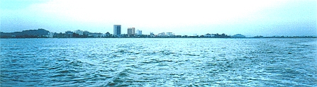  Strolling the river 'muara', viewed from Seberang Takir-Kg Batin on the northern bank, from right to left, from Hiliran, Pulau Kambing, through Balik Bukit, Kedai Binjai, Kampong China, Kedai Payang, Shah Bandar (Padang Malaya), passing Tanjong, and out to the sea. (Notice Bukit Besar on the background at the right of each pic). |
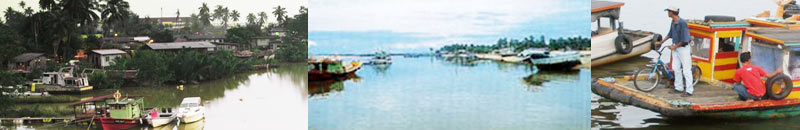 |
The northern bank was always dwelling areas, of poorer earner of mainly fishermen-based strata. Seberang takir at the lip, to Kg Batin, the islands, etc, etc, along the river. Terengganu river and its tributory Nerus river were the life vein through which food and other survival materials, including firewoods, were transported from the interior producing area to the 'metropolitan' consuming area.
Life were very merry. There once was a very lively symbiosis in the muara in every weather: hot, rainy, pacific, monsoon, windy, wavy, etc. Life on the water surface, in the water body, and in the soil of the river bed. On the surface, every producer intended to take their produces to Tanjong not so much for better price, but for bulk and quick sale so that they could return home as quickly. More people conggregated in Tanjong market place than in Kedai Binjai, or Kedai Payang.
Viewing Seberang Takir from Kampong Batin. |
Tanjong on the southern lip of the river 'orifice' (muara) is exactly as Seberang Takir on the northern lip. But the marine coastal evolution had changed both places in different way. The river flow in tango with the sea current of various fashion during dry and monsoon season, added by the recent river deswelling by the Kenyir dam had created a living machine that continually sculpting the coastal geomorphology. The product was that Seberang Takir was blessed with more and more deposits, perhaps at the expense of Tanjong which kept on being erroded. And unavoidably at the expense of the dwellers. Which eventually changed the demography. Unlike Seberang Takir which naturally had not altered the demography. NOT YET.
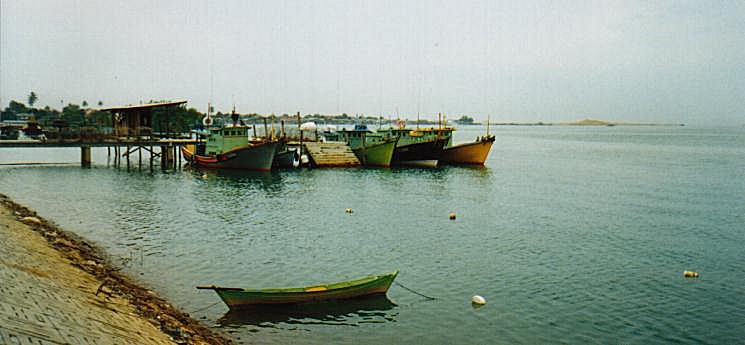
The silting and its migration had at one time gave a lot of trouble to the leaving and returning fishing boats. The "beting" had posed a real danger that with the pushing waves would sink the boats. Like this one in 2000 Dec.
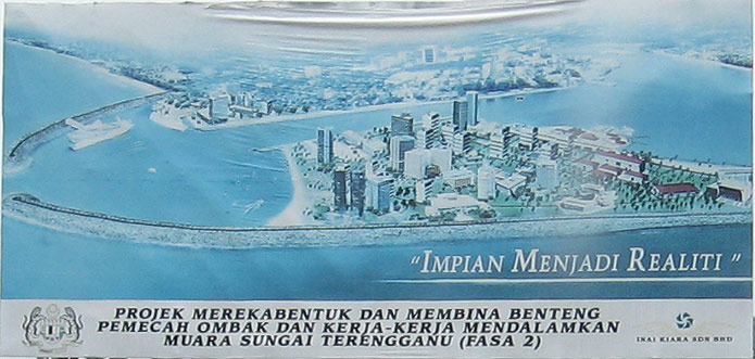 A massive programme was on the way that will change the muara of Terengganu river beyond the memory of any one who had a very intimate symbiotic life with it. Seberang takir, the foreground in the created pic on the left, and Tanjong on the opposite will change face like after a massive plastic surgery. The ex-face of which will be remembered only in the archive picture, if any. Ostensibly, new kind of life will spring up from the multi-million works spin off. Which will undeniably alter the demography. And judging from the picture will do most in Seberang Takir. Like Duyung will like become 'out-bound' to the locals because of the difference in the life activities. Nonetheless the wave breaker will keep the lips of the river from getting closer in the absence of pushing flow due to Kenyir, which will enable those sea-goers to continue enjoying the limitlessness of the sea. Unlike other rivers: Merang, Ibai and Paka. Marang and Besut were similarly saved. Kemaman perhaps would be next. |
 Viewing the muara from newly developed Duyung. K Terengganu is on the right, and Seberang Takir on the left. |
 Circular view of the wave breaker in the evolution. Buildings are seen springing in the Tanjong side. Seberang Takir side is still quiet. The sun rise in the east is seen on the right side of the pic. |

A large land area is reclaimed on the Tanjong side. The muara is visible in the middle of the picture. The Seberang Takir side is 'blessed' by the nature. Note the two posts of pilot light to guide the returning boats at night. |
The sand is digged from the middle of the estuary. But large boulders were carried to the area to hold the sand. Because of the near enclosure, the monsoon waves will be greatly tamed down. |

The sand and water is pump into a pool. The wall of the pool is maintained temporarily. The sand deposits, and the water decanted. |
The pool will eventually filled with sand. The border is slowly moved by ploughing the inside into the outside. |

To the tip of the breaker arc. |
From the Tanjong. |

Pilot light posts on the tips of the breaker. The green on Seberang Takir Post, and the red on Tanjong tip, so that the green is on the right, and the red is on the left of the returning boats. Previously the green was on the sand dune of Seberang Takir, and the red was on an island in the estuary. |
The red on the Tanjong tip |
 Distant returning boats were guided by this light on Bukit Besar before reaching the vicinity of the muara. Returning boats as far as from Bidong will see the light as a red band. Steering towards it would take to the muara, which would be welcomed by the pair of pilot lights.
 |
The green on the Seberang Takir tip |
 A Lot more to be digged between the jaw of the tips. |
The more vulnerable southern side. Note the Kapas island on the horizon. |
 Twenty kilometers down south, the muara of Marang, conceptually. |
The actual Marang. |